Your pocket-sized 3D scanning solution for any space.
Capture Site Geometry
Scan exteriors and interiors with just your mobile device to create precise 2D floor plans and 3D models.
Annotate in the Field
Add property lines, notes, easements, and dimensions directly on-site- no need to wait until you’re back in the office.
Integrate GPS Data
Seamlessly import GPS points via Bluetooth or AirDrop to align scans with geospatial accuracy.
Place Survey Objects On-Site
Drag and drop pre-defined survey blocks, like pools, driveways, or easements, directly onto the plan.
Attach Visual Evidence
Capture photos of key areas and link them to floor plans for context-rich surveys.
Sync Instantly to the Cloud
Upload data in real-time, ensuring office managers and drafting teams always have the latest version.
Export CAD-Ready Files
Generate DXF, DWG, and PDF outputs that align with CAD standards, ready for refinement or direct client delivery.
Features That Help You Map Smarter
Your pocket-sized 3D scanning solution for any space.
1
Seamless Field-to-Office Flow
From capture to CAD-ready outputs, QuickPlot bridges the gap between crews on-site and managers in the office.
2
Surveyor-Friendly Interface
No steep learning curve; intuitive tools designed for real-world field conditions.
3
Smart Data Integration
Combine scans, annotations, GPS, and photos into a single, organized project file.
4
Consistent CAD Standards
Exports align with Civil 3D conventions, ensuring accuracy and easy handoffs.
5
Cloud Reliability
Automatic backups and real-time sync keep your work secure and accessible anywhere.
6
Vendor-Ready Compatibility
Built-in integration with drafting vendors like Gsource for smooth outsourcing when needed.
How Quickplot Works
From Site to CAD — Automated, Accurate, Effortless.
1. Create Jobs
Upload plats, set job type, and assign survey crews or drafters — all in one dashboard.
2. Capture On-Site
Field teams use the Quickplot iOS App to scan, sketch, and collect site data with live map tracking.
3. AI-Powered Drafting
AWS automation drafts base lot outlines and extracts key metadata from plats and documents.
4. Draft & Validate
Drafters complete precision linework in QCAD, powered by automated QC checks.
5. Deliver & Bill
QA managers approve final files (DXF + PDF) and trigger instant, audit-clean client delivery.
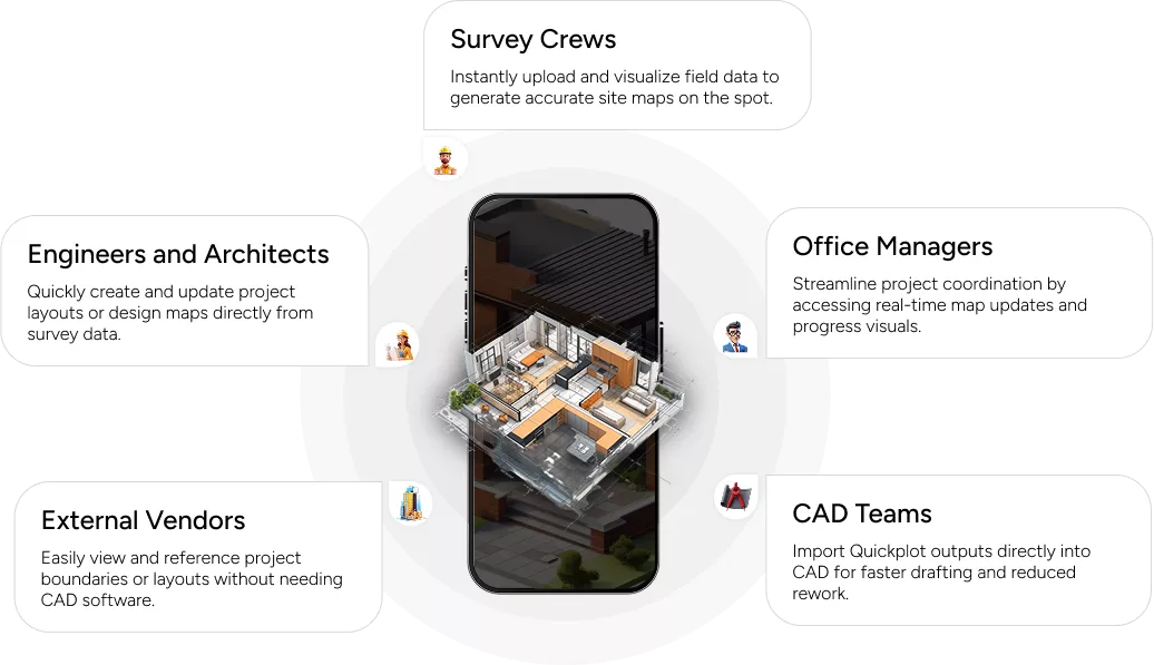
Who Uses Quickplot?
Great for every professional in the property and survey workflow
What’s Inside Quickplot?
Spaceview’s Appraiser module brings structure and simplicity to complex property evaluations, ensuring every report is complete, compliant, and ready for professional use. Here’s what it helps you capture:
1
Quickplot iOS App
Field job viewer, Google Maps integration, offline data capture.
2
Quickplot Cloud
Field teams use the Quickplot iOS App to scan, sketch, and collect site data with live map tracking.
3
AWS AI Services
Auto-drafts lot boundaries and extracts property data from plats.
4
Queue & File Manager
Manages documents, QC reports, and version history.
Hear it From our Users
Don’t take our word for it – take theirs.
Louis Farber
Land Surveyor
“Quickplot is a game-changer for mortgage survey drafting. It cuts out the tedious steps and saves me hours of work.”
Martina Lopez
Survey Office Manager
“With Quickplot, my field team and I stay perfectly synced. No more chasing files or redoing drawings back at the office.”
Jenna Kim
Interior Designer
“We highly recommend Mapperty! It has transformed the way we present spaces to clients. The 3D visuals make presentations so much more engaging.”
Blogs
Scan Tips
Heading Heading Heading Heading :
Heading
Streamline project execution with precise layouts and easy revision handling. Streamline project execution with precise layouts and easy revision handling.Streamline project execution with precise layouts and easy revision handling.
Scan Tips
Heading Heading Heading Heading :
Heading
Streamline project execution with precise layouts and easy revision handling. Streamline project execution with precise layouts and easy revision handling.Streamline project execution with precise layouts and easy revision handling.
Scan Tips
Heading Heading Heading Heading :
Heading
Streamline project execution with precise layouts and easy revision handling. Streamline project execution with precise layouts and easy revision handling.Streamline project execution with precise layouts and easy revision handling.
FAQs
What is Mapperty Estimator?
Mapperty Estimator is a smart application designed to simplify property damage inspection for insurance claim adjusters. It streamlines the claim process by minimizing manual work.
Who can benefit from Mapperty?
Mapperty Estimator is tailored for insurance companies, claim adjusters , policy holders, homeowners, contractors, and insurance attorneys. By providing claim estimation in a single day, it expedites the claim process for these professionals increasing their work efficiency.
How does Mapperty minimize manual work for claim adjusters?
Mapperty Estimator replaces traditional manual processes, allowing adjusters to digitize property inspections, generate reports, and manage projects seamlessly.
Does Mapperty provide chat support?
Yes, based on the selected plan, customer support will be provided by Mapperty. A dedicated account manager will be assigned to eligible plan holders. For general queries, clients can fill out a form or contact the support team via email.